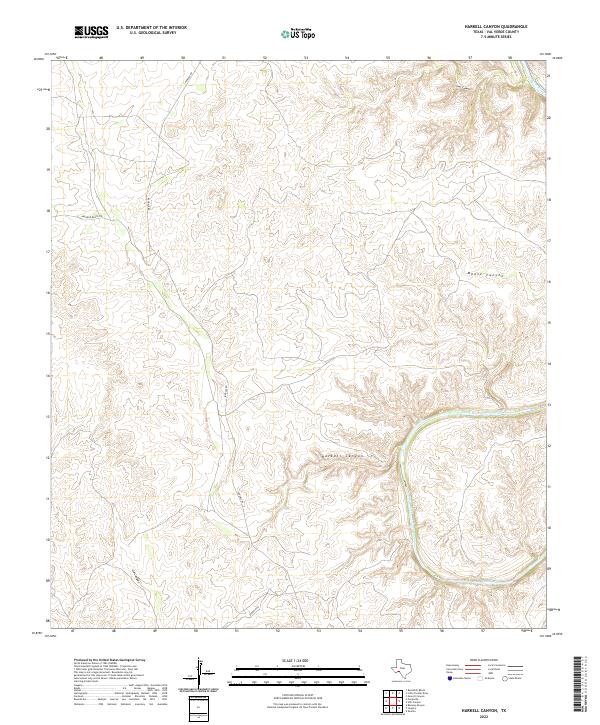
2022 Map of Harkell Canyon
USGS Topo · Published 2022About this map
Pecos River cuts a deep path through this portion of Val Verde County, defining the drainage patterns of the surrounding plateau. The landscape is heavily dissected by several named dry washes and canyons, most notably Harkell Canyon and Goat Canyon in the north, while G4 Canyon marks the southwestern quadrant. Access to this isolated ranching country is provided by a thin network of unpaved roads, including Pandale Rd and Arledge Ranch Rd. The intricate contouring reveals a topography where vertical relief is the dominant feature, as the terrain drops sharply toward the riverbed from the high, flat-topped divides. This 2022 survey provides a modern look at a region where the traditional ranching economy persists in a landscape largely unchanged by urbanization, emphasizing the natural boundary of the Moose Canyon system.
Find a feature on this map
7 named features on this map. Tap any name to fly to it.
Don’t see what you’re looking for? This feature index may not catch every label — zoom into the map to look around manually.
Map Details
Editions of this 2022 Harkell Canyon Map
This is the sole edition of this map. No revisions or reprints were ever made.
Other maps of this area

1943 · Langtry
USGS Topo · 1:62,500

1943 · Shumla
USGS Topo · 1:62,500

1954 · Sonora
USGS Topo · 1:250,000

1958 · Sonora
USGS Topo · 1:250,000

1958 · Del Rio
USGS Topo · 1:250,000

1964 · Del Rio
USGS Topo · 1:250,000

1970 · Everett Canyon
USGS Topo · 1:24,000

1970 · Little Fielder Draw
USGS Topo · 1:24,000

1973 · Langtry
USGS Topo · 1:24,000
1973 · Still Canyon
USGS Topo · 1:24,000