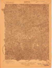
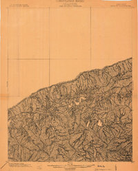
1916 Map of Harlan
USGS Topo · Published 1916About this map
Harlan serves as the focal point of this 1916 survey, situated at the confluence of the Cumberland River and several major forks. The landscape is dominated by the massive parallel ridges of Pine Mountain and Black Mountain, which dictate the location of early development. High up on the slopes of Black Mountain, the presence of an Incline near Black Joe and Caxton hints at the burgeoning coal industry that would soon transform this region's economy. Smaller mining and timber settlements like White Star and Kitts are scattered along the narrow valley floors. Away from the main river corridor, the terrain remains densely dissected by countless named branches and creeks, such as Wallins Creek and Greasy Creek, where the Pine Branch School provided a center for local rural life during the early twentieth century.
Find a feature on this map
63 named features on this map. Tap any name to fly to it.
Don’t see what you’re looking for? This feature index may not catch every label — zoom into the map to look around manually.
Map Details
Editions of this 1916 Harlan Map
This is the sole edition of this map. No revisions or reprints were ever made.
Other maps of this area

1886 · Cumberland Gap
USGS Topo · 1:125,000

1887 · Jonesville
USGS Topo · 1:125,000

1888 · Cumberland Gap
USGS Topo · 1:125,000

1891 · Manchester
USGS Topo · 1:125,000

1891 · Cumberland Gap
USGS Topo · 1:125,000

1891 · Hazard
USGS Topo · 1:125,000

1891 · Jonesville
USGS Topo · 1:125,000
1903 · Harlan
USGS Topo · 1:48,000

1903 · Pineville
USGS Topo · 1:48,000

1903 · Middlesboro
USGS Topo · 1:48,000