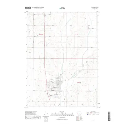
2018 Map of Harlan
USGS Topo · Published 2018About this map
The West Fork West Nishnabotna River and West Nishnabotna River converge south of the settlement of Kirkman, defining the drainage patterns of this Shelby County landscape. The town of Harlan occupies the southwest quadrant, showing a detailed street grid including Broadway St, Main St, and Cyclone Ave. This 2018 survey reveals a landscape where modern infrastructure like Street F32 and Industrial Pkwy coexists with long-established landmarks. Genealogists will find several burial grounds noted, including Harlan Cem near the town center, and the more remote Rose Hill Cem and Rabbit Hallow Cem to the east. The terrain is further marked by several water features such as Silver Cr and Little George Lake, illustrating the transition from urban settlement to the surrounding agricultural sections.
Find a feature on this map
49 named features on this map. Tap any name to fly to it.
Don’t see what you’re looking for? This feature index may not catch every label — zoom into the map to look around manually.
Map Details
Editions of this 2018 Harlan Map
This is the sole edition of this map. No revisions or reprints were ever made.
Other maps of this area

1954 · Omaha
USGS Topo · 1:250,000

1957 · Omaha
USGS Topo · 1:250,000

1958 · Omaha
USGS Topo · 1:250,000

1971 · Earling
USGS Topo · 1:24,000

1971 · Defiance
USGS Topo · 1:24,000

1978 · Panama
USGS Topo · 1:24,000

1978 · Irwin
USGS Topo · 1:24,000

1978 · Corley
USGS Topo · 1:24,000

1978 · Prairie Rose Lake
USGS Topo · 1:24,000
1978 · Harlan
USGS Topo · 1:24,000