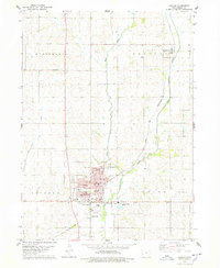
1978 Map of Harlan
USGS Topo · Published 1978About this map
The West Fork Nishnabotna River winds through Shelby County, anchoring a landscape defined by traditional Midwestern town planning and agricultural transport. Harlan serves as the dominant hub, centered on its Courthouse and Po (Post Office), with a density of civic infrastructure including the Central Jr High Sch and multiple municipal parks like Potters Park. The map documents a community in transition, showing the active Chicago and North Western line alongside an Old Railroad Grade, tracing the evolution of the local rail economy.
Find a feature on this map
30 named features on this map. Tap any name to fly to it.
Don’t see what you’re looking for? This feature index may not catch every label — zoom into the map to look around manually.
Map Details
Editions of this 1978 Harlan Map
This is the sole edition of this map. No revisions or reprints were ever made.
Other maps of this area

1954 · Omaha
USGS Topo · 1:250,000

1957 · Omaha
USGS Topo · 1:250,000

1958 · Omaha
USGS Topo · 1:250,000

1971 · Earling
USGS Topo · 1:24,000

1971 · Defiance
USGS Topo · 1:24,000

1978 · Panama
USGS Topo · 1:24,000

1978 · Irwin
USGS Topo · 1:24,000

1978 · Corley
USGS Topo · 1:24,000

1978 · Prairie Rose Lake
USGS Topo · 1:24,000
1978 · Shelby
USGS Topo · 1:24,000