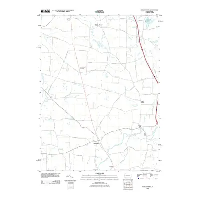
2010 Map of Harlansburg
USGS Topo · Published 2010About this map
Harlansburg serves as a central hub in this western Pennsylvania landscape, where the waters of Slippery Rock Creek wind through the countryside near Rockville. The area reflects a blend of traditional agricultural life and recreational spaces, featuring both the Shaw Dairy Farm Airport and the Meadowlark Farm Airport. Local history is anchored by sites such as the Stevenson Cemetery and the settlement of Elliotts Mills situated along the creek's path. Small clusters like Plain Grove, Drake, and Brent are connected by a network of rural roads including Pollock Store Rd and Jackson School Rd, names that point to the historical community structures of the region. Leisure and community activities are evidenced by the Green Meadows Golf Course, Camp Rentz, and Deep Valley Camp, illustrating how the land around the Lawrence and Butler county lines has been utilized for both residence and retreat.
Find a feature on this map
69 named features on this map. Tap any name to fly to it.
Don’t see what you’re looking for? This feature index may not catch every label — zoom into the map to look around manually.
Map Details
Editions of this 2010 Harlansburg Map
This is the sole edition of this map. No revisions or reprints were ever made.
Other maps of this area

1902 · New Castle
USGS Topo · 1:62,500

1904 · Newcastle
USGS Topo · 1:62,500

1905 · Neshannock
USGS Topo · 1:62,500

1907 · Neshannock
USGS Topo · 1:62,500

1908 · Zelienople
USGS Topo · 1:62,500

1910 · Zelienople
USGS Topo · 1:62,500

1913 · Mercer
USGS Topo · 1:62,500

1939 · Mercer
USGS Topo · 1:62,500

1943 · Mercer
USGS Topo · 1:62,500

1950 · Cleveland
USGS Topo · 1:250,000
Featured Places
- Plain Grove Township, PA
- Rockville, Scott Township
- Worth Township, PA
- Washington Township, PA
- Springfield Township, PA