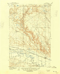
1905 Map of Harlem
USGS Topo · Published 1949About this map
Harlem serves as the primary hub along the northern bank of the Milk River, situated at a vital junction of the Great Northern R R and early irrigation projects. The map illustrates a transitional landscape where the river's meandering course is harnessed by the Harlem Canal and Paradise Canal to support the valley's agricultural development. South of the river, the Fort Belknap Indian Reservation extends across the territory, while the northern uplands are punctuated by early cattle operations such as Sortersform's Ranch and Arbagast's Ranch. Numerous seasonal drainages including Thirty-mile Creek, Fogey Creek, and Snake Creek carve through the breaks, revealing the complex drainage patterns that defined ranching and movement in this part of Blaine County during the early twentieth century.
Find a feature on this map
14 named features on this map. Tap any name to fly to it.
Don’t see what you’re looking for? This feature index may not catch every label — zoom into the map to look around manually.
Map Details
Editions of this 1905 Harlem Map
2 editions found
Other maps of this area

1903 · Wayne Creek
USGS Topo · 1:62,500

1904 · Chinook
USGS Topo · 1:62,500

1905 · Wayne Creek
USGS Topo · 1:62,500

1905 · Harlem
USGS Topo · 1:62,500

1912 · Zurich
USGS Topo · 1:125,000

1913 · Cherry Ridge
USGS Topo · 1:125,000

1953 · Havre
USGS Topo · 1:250,000

1956 · Cleveland
USGS Topo · 1:62,500

1957 · Havre
USGS Topo · 1:250,000

1958 · Havre
USGS Topo · 1:250,000