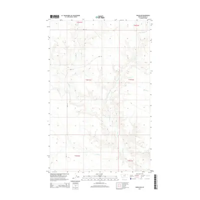
2014 Map of Harlem NW
USGS Topo · Published 2014About this map
Thirtymile Cr and its tributaries define the drainage patterns of this Blaine County landscape. The map details the rural expanses of northern Montana, where the terrain is marked by the winding courses of E Br Thirtymile Cr, Forgey Cr, and Nessler Cr. This 2014 survey documents a region dominated by the Public Land Survey System, showing the township and range divisions of T33N through T35N. Human activity is evidenced by Oberg Rd, which provides one of the few named navigational routes through the high plains. The lack of concentrated settlements highlights the open, agricultural, or grazing character of the land at the time of this survey, making it a valuable record for researchers tracking land ownership and rural infrastructure in the early 21st century.
Find a feature on this map
11 named features on this map. Tap any name to fly to it.
Don’t see what you’re looking for? This feature index may not catch every label — zoom into the map to look around manually.
Map Details
Editions of this 2014 Harlem NW Map
This is the sole edition of this map. No revisions or reprints were ever made.
Other maps of this area

1904 · Chinook
USGS Topo · 1:62,500

1905 · Harlem
USGS Topo · 1:62,500

1912 · Zurich
USGS Topo · 1:125,000

1913 · Cherry Ridge
USGS Topo · 1:125,000

1953 · Havre
USGS Topo · 1:250,000

1957 · Havre
USGS Topo · 1:250,000

1958 · Havre
USGS Topo · 1:250,000
1964 · Fort Belknap Siding
USGS Topo · 1:24,000
1964 · Harlem
USGS Topo · 1:24,000
1964 · Zurich
USGS Topo · 1:24,000