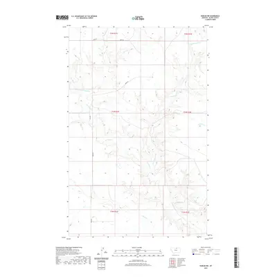
2020 Map of Harlem NW
USGS Topo · Published 2020About this map
Thirtymile Cr and its complex network of seasonal tributaries define the landscape of this Blaine County region. The drainage system, including the E Br Thirtymile Cr and the Northwest Fork Thirtymile Cr, cuts through the terrain north of Harlem. This 2020 survey illustrates a sparsely populated ranching or agricultural area where human activity is primarily marked by section lines and the path of Oberg Rd. The map provides a detailed view of the local hydrography, showing how smaller channels like Nessler Cr and W Forgey Cr feed into the larger creek system, reflecting the water-dependent topography of the northern plains.
Find a feature on this map
12 named features on this map. Tap any name to fly to it.
Don’t see what you’re looking for? This feature index may not catch every label — zoom into the map to look around manually.
Map Details
Editions of this 2020 Harlem NW Map
This is the sole edition of this map. No revisions or reprints were ever made.
Other maps of this area

1904 · Chinook
USGS Topo · 1:62,500

1905 · Harlem
USGS Topo · 1:62,500

1912 · Zurich
USGS Topo · 1:125,000

1913 · Cherry Ridge
USGS Topo · 1:125,000

1953 · Havre
USGS Topo · 1:250,000

1957 · Havre
USGS Topo · 1:250,000

1958 · Havre
USGS Topo · 1:250,000
1964 · Fort Belknap Siding
USGS Topo · 1:24,000
1964 · Harlem
USGS Topo · 1:24,000
1964 · Zurich
USGS Topo · 1:24,000