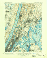
1897 Map of Harlem
USGS Topo · Published 1960About this map
Yonkers Park and the burgeoning suburban reaches of Westchester County meet the dense urban grid of Manhattan and the Bronx in this late 19th-century survey. The landscape is defined by the massive engineering works of a growing metropolis, featuring the Croton Aqueduct and Old Croton Aqueduct snaking through the terrain to the Jerome Park Reservoir. Along the Hudson River, the dramatic Palisades loom over the West Shore RR on the New Jersey side, while the New York shore reveals landmarks like Grants Tomb and the expansive Riverside Park.
Find a feature on this map
173 named features on this map. Tap any name to fly to it.
Don’t see what you’re looking for? This feature index may not catch every label — zoom into the map to look around manually.
Map Details
Editions of this 1897 Harlem Map
4 editions found

Other maps of this area

1888 · Paterson
USGS Topo · 1:62,500

1889 · Brooklyn
USGS Topo · 1:62,500

1891 · Ramapo
USGS Topo · 1:62,500

1891 · Brooklyn
USGS Topo · 1:62,500

1891 · Harlem
USGS Topo · 1:62,500

1892 · Stamford
USGS Topo · 1:62,500

1892 · Paterson
USGS Topo · 1:62,500

1892 · Tarrytown
USGS Topo · 1:62,500

1893 · Stamford
USGS Topo · 1:62,500

1893 · Tarrytown
USGS Topo · 1:62,500