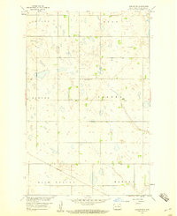
1958 Map of Harlow SW
USGS Topo · Published 1960About this map
Glacial prairie potholes and scattered wetlands define the landscape of Benson County in the late 1950s, a period when the rural section lines still dictated the pattern of life and travel. The Northern Pacific railway cuts a diagonal path across the southwest corner of the sheet, providing the primary industrial link through the townships of Rich Valley and Hesper. This survey captures the small settlement of Isabel and the community anchors of Bethany Ch and Immanuel Ch, which served the surrounding farmsteads across Isabel, Esmond, and Broe townships. The map is a product of the Department of the Interior's program for the development of the Missouri River Basin, documenting a high-plains terrain characterized more by its drainage patterns and small depressions than by significant elevation changes, preserving the spatial layout of central North Dakota just before modern agricultural consolidation.
Find a feature on this map
10 named features on this map. Tap any name to fly to it.
Don’t see what you’re looking for? This feature index may not catch every label — zoom into the map to look around manually.
Map Details
Editions of this 1958 Harlow SW Map
This is the sole edition of this map. No revisions or reprints were ever made.
Other maps of this area

1941 · Selz
USGS Topo · 1:62,500

1943 · Maddock
USGS Topo · 1:62,500

1945 · Maddock
USGS Topo · 1:62,500

1951 · Selz NE
USGS Topo · 1:24,000

1951 · Maddock
USGS Topo · 1:24,000

1951 · Hesper
USGS Topo · 1:24,000

1952 · New Rockford
USGS Topo · 1:250,000

1953 · Devils Lake
USGS Topo · 1:250,000

1956 · New Rockford
USGS Topo · 1:250,000

1956 · Devils Lake
USGS Topo · 1:250,000