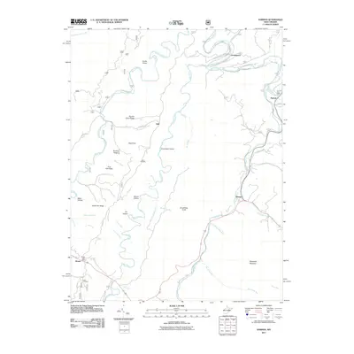
2011 Map of Harman
USGS Topo · Published 2011About this map
The mountain valleys of the Glady Fork and Dry Fork rivers define this 2011 survey, showing the interconnectedness of rural West Virginia settlements at the start of the decade. The small communities of Harman and Wymer serve as local hubs, each still maintaining its own post office at this time, including the Wymer Post Office and the Dry Fork Post Office further north. The landscape is heavily influenced by the winding watercourses and the ridgelines they carve, such as Krafts Ridge and Panther Camp Ridge. Genealogy interests are served by the presence of family-named sites like Kerns Cemetery near Hog Knob and White Cemetery in the southern portion of the quadrangle. The naming conventions throughout the area, from Coon Bone Island to Brierpatch Mountain, reflect a deeply rooted local geography tied to the terrain's specific character and the historic patterns of mountain life.
Find a feature on this map
53 named features on this map. Tap any name to fly to it.
Don’t see what you’re looking for? This feature index may not catch every label — zoom into the map to look around manually.
Map Details
Editions of this 2011 Harman Map
This is the sole edition of this map. No revisions or reprints were ever made.
Other maps of this area

1886 · St. George
USGS Topo · 1:125,000

1889 · Beverly
USGS Topo · 1:125,000

1891 · St. George
USGS Topo · 1:125,000

1892 · Beverly
USGS Topo · 1:125,000

1892 · Franklin
USGS Topo · 1:125,000

1895 · Piedmont
USGS Topo · 1:125,000

1896 · Franklin
USGS Topo · 1:125,000

1908 · Parsons
USGS Topo · 1:62,500

1916 · Davis
USGS Topo · 1:48,000

1918 · Davis
USGS Topo · 1:62,500