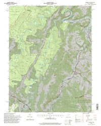
1995 Map of Harman
USGS Topo · Published 1998About this map
The Monongahela National Forest dominates this landscape, where the high ridges of Shavers Mountain and Laurel Mountain dictate the flow of the land. Small communities such as Harman, Dryfork, and Wymer are positioned along the river valleys, while more isolated settlements like Sully occupy the higher benches near Panther Camp Ridge. The confluence of the Dry Fork and Glady Fork serves as a focal point for local geography, with the historic Riverside Ch and Roadside Park located near the water.
Find a feature on this map
50 named features on this map. Tap any name to fly to it.
Don’t see what you’re looking for? This feature index may not catch every label — zoom into the map to look around manually.
Map Details
Editions of this 1995 Harman Map
2 editions found
Other maps of this area

1886 · St. George
USGS Topo · 1:125,000

1889 · Beverly
USGS Topo · 1:125,000

1891 · St. George
USGS Topo · 1:125,000

1892 · Beverly
USGS Topo · 1:125,000

1892 · Franklin
USGS Topo · 1:125,000

1895 · Piedmont
USGS Topo · 1:125,000

1896 · Franklin
USGS Topo · 1:125,000

1908 · Parsons
USGS Topo · 1:62,500

1916 · Davis
USGS Topo · 1:48,000

1918 · Davis
USGS Topo · 1:62,500