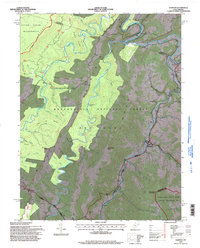
1995 Map of Harman
USGS Topo · Published 1998About this map
Harman and the winding Dry Fork anchor this 1990s topographic record of the Allegheny Highlands, documenting a landscape where deep watercuts and high ridges dictate the pattern of settlement. Following the river valleys, small communities like Jenningston and Dryfork persist along the winding corridors between Laurel Mountain and Shavers Mountain. Much of the area is defined by federal land protections, including the Otter Creek Wilderness and the Spruce Knob - Seneca Rocks National Recreation Area, where the rugged topography remains largely undeveloped save for logging and hiking paths like the Shavers Mountain Trail. Local genealogy is preserved in numerous scattered cemeteries and named landmarks such as Coon Bone Island and Brushheap Knob, reflecting a century of life in the high Monongahela National Forest.
Find a feature on this map
53 named features on this map. Tap any name to fly to it.
Don’t see what you’re looking for? This feature index may not catch every label — zoom into the map to look around manually.
Map Details
Editions of this 1995 Harman Map
2 editions found
Other maps of this area

1886 · St. George
USGS Topo · 1:125,000

1889 · Beverly
USGS Topo · 1:125,000

1891 · St. George
USGS Topo · 1:125,000

1892 · Beverly
USGS Topo · 1:125,000

1892 · Franklin
USGS Topo · 1:125,000

1895 · Piedmont
USGS Topo · 1:125,000

1896 · Franklin
USGS Topo · 1:125,000

1908 · Parsons
USGS Topo · 1:62,500

1916 · Davis
USGS Topo · 1:48,000

1918 · Davis
USGS Topo · 1:62,500