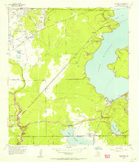
1954 Map of Harmaston
USGS Topo · Published 1956About this map
Harmaston sits along the Missouri Pacific line in this mid-1950s survey of eastern Harris County, a landscape defined by its transition toward massive water management projects. The sheet documents the early footprint of Lake Houston and the Sheldon Reservoir, including the extensive Levee system and an Intake Tower near the San Jacinto R. The area’s industrial character is marked by numerous pipelines and oil-related infrastructure, such as the Oil Pumping Sta and various storage pits.
Find a feature on this map
27 named features on this map. Tap any name to fly to it.
Don’t see what you’re looking for? This feature index may not catch every label — zoom into the map to look around manually.
Map Details
Editions of this 1954 Harmaston Map
This is the sole edition of this map. No revisions or reprints were ever made.
Other maps of this area

1916 · Burnett Bay
USGS Topo · 1:24,000

1916 · Crosby
USGS Topo · 1:24,000

1916 · Settegast
USGS Topo · 1:24,000

1916 · Fauna
USGS Topo · 1:24,000

1916 · Harmaston
USGS Topo · 1:24,000

1916 · Moonshine Hill
USGS Topo · 1:24,000

1916 · Huffman
USGS Topo · 1:24,000

1916 · Humble
USGS Topo · 1:24,000

1919 · Humble
USGS Topo · 1:31,680

1919 · Weeden
USGS Topo · 1:31,680