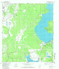
1982 Map of Harmaston
USGS Topo · Published 1982About this map
Lake Houston dominates the eastern half of this 1982 landscape, serving as a focal point for late 20th-century development and conservation on the outskirts of Harris County. The map documents the expansion of Houston as it encompasses newly established communities like Lake Shadows and the Atascocita Forest residential pocket. To the west, the Riverside Oil Field and numerous scattered Oil Wells illustrate the continued importance of the petroleum industry to the regional economy.
Find a feature on this map
44 named features on this map. Tap any name to fly to it.
Don’t see what you’re looking for? This feature index may not catch every label — zoom into the map to look around manually.
Map Details
Editions of this 1982 Harmaston Map
This is the sole edition of this map. No revisions or reprints were ever made.
Other maps of this area

1916 · Burnett Bay
USGS Topo · 1:24,000

1916 · Crosby
USGS Topo · 1:24,000

1916 · Settegast
USGS Topo · 1:24,000

1916 · Fauna
USGS Topo · 1:24,000

1916 · Harmaston
USGS Topo · 1:24,000

1916 · Moonshine Hill
USGS Topo · 1:24,000

1916 · Huffman
USGS Topo · 1:24,000

1916 · Humble
USGS Topo · 1:24,000

1919 · Humble
USGS Topo · 1:31,680

1919 · Weeden
USGS Topo · 1:31,680