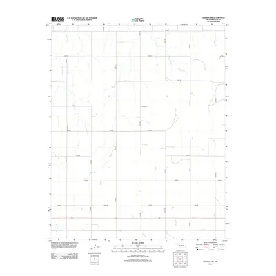
2012 Map of Harmon NW
USGS Topo · Published 2012About this map
Little Wolf Cr and Buzzard Cr drain this section of the High Plains in Oklahoma's northwestern corner, following a natural north-south drainage pattern that has long dictated the layout of regional ranching and agricultural operations. The landscape is defined by a rigid section-line road network, where routes like E0530 Rd and N1850 Rd square off the terrain into predictable parcels. This grid system, characteristic of the state's land survey history, stands in contrast to the meandering paths of Mosquito Cr in the southwest. The area remains sparsely populated and focused on land management, with small water catchment features scattered among the ephemeral stream beds. This USGS study provides a clear view of the rural infrastructure and natural hydrology in Ellis County shortly after the turn of the 21st century.
Find a feature on this map
19 named features on this map. Tap any name to fly to it.
Don’t see what you’re looking for? This feature index may not catch every label — zoom into the map to look around manually.
Map Details
Editions of this 2012 Harmon NW Map
This is the sole edition of this map. No revisions or reprints were ever made.
Other maps of this area

1955 · Woodward
USGS Topo · 1:250,000

1958 · Woodward
USGS Topo · 1:250,000

1969 · Fargo SW
USGS Topo · 1:24,000

1969 · Gage
USGS Topo · 1:24,000

1969 · Fargo SE
USGS Topo · 1:24,000

1970 · Arnett
USGS Topo · 1:24,000

1970 · Harmon
USGS Topo · 1:24,000

1970 · Arnett SE
USGS Topo · 1:24,000

1970 · Harmon SW
USGS Topo · 1:24,000
1970 · Harmon SE
USGS Topo · 1:24,000