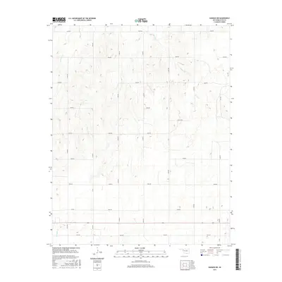
2016 Map of Harmon NW
USGS Topo · Published 2016About this map
Little Wolf Cr and Buzzard Cr drain the dissected plains of northern Ellis County, where the landscape is defined by a rigorous grid of section-line roads. This survey reveals a region dominated by ranching and resource extraction, notably marked by Oil Field RD, which serves the petroleum infrastructure north of the Ew 60 corridor. The drainage patterns of Mosquito Cr in the southwest corner illustrate the natural erosion of the plateau, contrasting with the geometric precision of the county's transportation network. While largely open country, the map tracks several numbered and lettered routes like NS 184 and e0590 RD that provide access to this rural Oklahoma territory.
Find a feature on this map
23 named features on this map. Tap any name to fly to it.
Don’t see what you’re looking for? This feature index may not catch every label — zoom into the map to look around manually.
Map Details
Editions of this 2016 Harmon NW Map
This is the sole edition of this map. No revisions or reprints were ever made.
Other maps of this area

1955 · Woodward
USGS Topo · 1:250,000

1958 · Woodward
USGS Topo · 1:250,000

1969 · Fargo SW
USGS Topo · 1:24,000

1969 · Gage
USGS Topo · 1:24,000

1969 · Fargo SE
USGS Topo · 1:24,000

1970 · Arnett
USGS Topo · 1:24,000

1970 · Harmon
USGS Topo · 1:24,000

1970 · Arnett SE
USGS Topo · 1:24,000

1970 · Harmon SW
USGS Topo · 1:24,000
1970 · Harmon SE
USGS Topo · 1:24,000