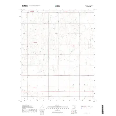
2018 Map of Harmon NW
USGS Topo · Published 2018About this map
The rolling drainage basins of Ellis County are defined by seasonal watercourses like Little Wolf Cr and Buzzard Cr as they cut through the northwestern Oklahoma plains. The landscape is organized by a precise grid of sectional roads, with the intersection of N1850 Rd and several east-west routes facilitating movement across the sparsely populated terrain. Industrial activity is concentrated along the appropriately named Oil Field Rd, reflecting the regional reliance on energy extraction during the early 21st century. In the southern portion of the sheet, Mosquito Cr meanders through the plains near E0610 Rd, illustrating the characteristic prairie topography where wide-open sections are punctuated only by these occasional creek beds and a network of service roads.
Find a feature on this map
29 named features on this map. Tap any name to fly to it.
Don’t see what you’re looking for? This feature index may not catch every label — zoom into the map to look around manually.
Map Details
Editions of this 2018 Harmon NW Map
This is the sole edition of this map. No revisions or reprints were ever made.
Other maps of this area

1955 · Woodward
USGS Topo · 1:250,000

1958 · Woodward
USGS Topo · 1:250,000

1969 · Fargo SW
USGS Topo · 1:24,000

1969 · Gage
USGS Topo · 1:24,000

1969 · Fargo SE
USGS Topo · 1:24,000

1970 · Arnett
USGS Topo · 1:24,000

1970 · Harmon
USGS Topo · 1:24,000

1970 · Arnett SE
USGS Topo · 1:24,000

1970 · Harmon SW
USGS Topo · 1:24,000
1970 · Harmon SE
USGS Topo · 1:24,000