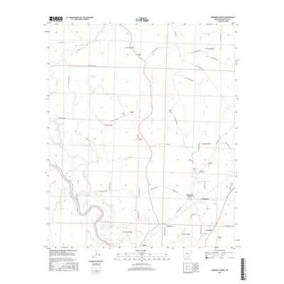
2017 Map of Harmony Grove
USGS Topo · Published 2017About this map
The winding course of the Ouachita River defines the southern portion of this landscape, creating a complex hydrologic network of oxbows and sloughs including Lower Old River, Fishers Lake, and Toney Old River. The terrain transitions from the river bottomlands to the settled highlands of Harmony Grove and Vanduzer, where local road networks such as Quachita Road 88 and Princeton Rd connect family-named landmarks. Several historic burying grounds, including Harmony Grove Cem, Broughton Cem, and Martin Cem, provide critical data points for genealogists researching the area's early residents. Further south, Camark and Harrell Field mark the vicinity of Kent and Warner, where the land is carved by Mizzell Cr and Palmer Bayou. In the northern section, small creek systems like Tulip Cr and Chapel Cr drain toward Big Dixon Lake, surrounding the small settlements of Amy and Velie.
Find a feature on this map
66 named features on this map. Tap any name to fly to it.
Don’t see what you’re looking for? This feature index may not catch every label — zoom into the map to look around manually.
Map Details
Editions of this 2017 Harmony Grove Map
This is the sole edition of this map. No revisions or reprints were ever made.
Other maps of this area

1903 · Camden
USGS Topo · 1:125,000

1951 · Camden
USGS Topo · 1:24,000

1953 · El Dorado
USGS Topo · 1:250,000

1957 · El Dorado
USGS Topo · 1:250,000

1958 · El Dorado
USGS Topo · 1:250,000

1960 · El Dorado
USGS Topo · 1:250,000

1971 · Tates Bluff
USGS Topo · 1:24,000

1971 · Ouachita
USGS Topo · 1:24,000
1971 · Harmony Grove
USGS Topo · 1:24,000
1971 · Camden
USGS Topo · 1:24,000