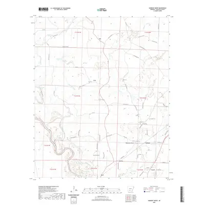
2020 Map of Harmony Grove
USGS Topo · Published 2020About this map
The Ouachita River defines the southern boundary of this region, its winding course creating a landscape of oxbows and secondary waterways like Toney Old River, Fishers Lake, and Palmer Bayou. The interior is marked by a network of rural settlements, including Amy, Velie, Harmony Grove, and Kent, connected by an extensive system of numbered county roads. This area of Ouachita County shows a classic South Arkansas pattern of dispersed communities anchored by local landmarks and memorial sites.
Find a feature on this map
74 named features on this map. Tap any name to fly to it.
Don’t see what you’re looking for? This feature index may not catch every label — zoom into the map to look around manually.
Map Details
Editions of this 2020 Harmony Grove Map
This is the sole edition of this map. No revisions or reprints were ever made.
Other maps of this area

1903 · Camden
USGS Topo · 1:125,000

1951 · Camden
USGS Topo · 1:24,000

1953 · El Dorado
USGS Topo · 1:250,000

1957 · El Dorado
USGS Topo · 1:250,000

1958 · El Dorado
USGS Topo · 1:250,000

1960 · El Dorado
USGS Topo · 1:250,000

1971 · Tates Bluff
USGS Topo · 1:24,000

1971 · Ouachita
USGS Topo · 1:24,000
1971 · Harmony Grove
USGS Topo · 1:24,000
1971 · Camden
USGS Topo · 1:24,000