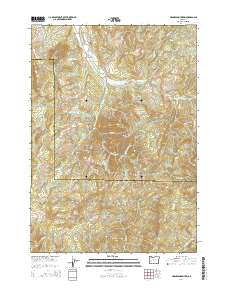
2014 Map of Harness Mountain
USGS Topo · Published 2014About this map
The Calapooya Divide serves as a prominent geographic spine in this 2014 survey, marking the rugged boundary between the Coast Fork Willamette River drainage to the north and the Little River system to the south. This transition zone between the Southern Willamette Valley and the Umpqua Basin is defined by steep ridges and numerous timber access routes, including Big River Rd and various BLM roads that crisscross the terrain. Historically significant landmarks include the Bemis Cem and Rouse Bridge, located near the intersection of London Rd and the headwaters of the Willamette. The presence of peaks like Black Butte, Cinnabar Mtn, and Harness Mountain indicates the area's complex volcanic and mineral history, while the proximity of the Douglas and Lane county line highlights the map's position at a key administrative junction in the Oregon Cascades.
Find a feature on this map
59 named features on this map. Tap any name to fly to it.
Don’t see what you’re looking for? This feature index may not catch every label — zoom into the map to look around manually.
Map Details
Editions of this 2014 Harness Mountain Map
This is the sole edition of this map. No revisions or reprints were ever made.
Other maps of this area

1897 · Roseburg
USGS Topo · 1:125,000

1900 · Roseburg
USGS Topo · 1:125,000

1935 · Lowell
USGS Topo · 1:96,000

1942 · Lowell
USGS Topo · 1:125,000

1954 · Anlauf
USGS Topo · 1:62,500

1954 · Glide
USGS Topo · 1:62,500

1955 · Mace Mtn
USGS Topo · 1:62,500

1955 · Culp Creek
USGS Topo · 1:62,500

1958 · Roseburg
USGS Topo · 1:250,000

1959 · Roseburg
USGS Topo · 1:250,000