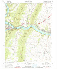
1969 Map of Harpers Ferry
USGS Topo · Published 1991About this map
The Potomac River and Shenandoah River converge at the heart of this survey, carving through the massive ridges of the Blue Ridge and South Mountain. This landscape serves as a critical junction of transportation history, where the Baltimore and Ohio Railroad and the Chesapeake and Ohio Canal parallel the water's edge. The map highlights the complex boundaries of Maryland, Virginia, and West Virginia, centering on the preserved grounds of Harpers Ferry National Historical Park. Away from the river, the terrain rises sharply toward Loudoun Heights and Elk Ridge, while the eastern plains support established communities like Brunswick and Lovettsville. Local heritage is anchored by country landmarks such as Garretts Mill and numerous rural houses of worship, including St Pauls Ch and New Jerusalem Ch, which served the small settlements and farming valleys of the late 1960s.
Find a feature on this map
65 named features on this map. Tap any name to fly to it.
Don’t see what you’re looking for? This feature index may not catch every label — zoom into the map to look around manually.
Map Details
Editions of this 1969 Harpers Ferry Map
3 editions found
Other maps of this area

1884 · Harpers Ferry
USGS Topo · 1:125,000

1891 · Harpers Ferry
USGS Topo · 1:125,000

1893 · Harpers Ferry
USGS Topo · 1:125,000

1908 · Middletown
USGS Topo · 1:48,000

1910 · Antietam
USGS Topo · 1:62,500

1914 · Martinsburg
USGS Topo · 1:48,000

1916 · Martinsburg
USGS Topo · 1:62,500

1916 · Berryville
USGS Topo · 1:62,500

1939 · Berryville
USGS Topo · 1:48,000
1944 · Waterford
USGS Topo · 1:31,680