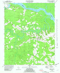
1982 Map of Harrellsville
USGS Topo · Published 1982About this map
Harrellsville sits at the heart of this landscape, where the terrestrial terrain meets a complex system of waterways and swamps in northeastern North Carolina. The community is anchored by the Harrellsville Chapel and nearby Cherry Sch, reflecting a settled rural economy. The geography is defined by the winding course of the Wiccacon River, which flows past Cotton Island toward its confluence with the broad Chowan River. Along these riverbanks, small settlements and access points like Pettys Shore, Eure Landing, and Cedar Hill Landing suggest a long history of water-based transport and commerce. Inland, the map reveals a mosaic of agriculture and wetlands, including Flat Swamp and Chinkapin Swamp. Significant rural landmarks such as Newsome Store and Pilands Crossroads serve as navigational nodes, while several scattered Cem (cemeteries) provide valuable touchpoints for genealogists tracing local families in Hertford and Gates counties.
Find a feature on this map
29 named features on this map. Tap any name to fly to it.
Don’t see what you’re looking for? This feature index may not catch every label — zoom into the map to look around manually.
Map Details
Editions of this 1982 Harrellsville Map
This is the sole edition of this map. No revisions or reprints were ever made.
Other maps of this area

1904 · Edenton
USGS Topo · 1:62,500

1906 · Beckford
USGS Topo · 1:48,000

1907 · Beckford
USGS Topo · 1:62,500

1908 · Winton
USGS Topo · 1:62,500

1940 · Beckford
USGS Topo · 1:62,500

1942 · Edenton
USGS Topo · 1:62,500

1943 · Edenton
USGS Topo · 1:62,500

1953 · Norfolk
USGS Topo · 1:250,000
1981 · Merchants Millpond
USGS Topo · 1:24,000
1981 · Gatesville
USGS Topo · 1:24,000