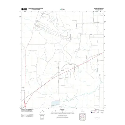
2013 Map of Harriet
USGS Topo · Published 2013About this map
The settlement of Harriet serves as a central point in this Tom Green County landscape, where agricultural land meets industrial testing facilities. The northern portion of the map is dominated by the sprawling automotive tracks of the Goodyear Proving Grounds, illustrating the intersection of West Texas geography and industrial utility. Rural life is anchored by several historic landmarks, including the Harriet School and Harriet Cem, which preserve the local heritage of this ranching and farming community.
Find a feature on this map
49 named features on this map. Tap any name to fly to it.
Don’t see what you’re looking for? This feature index may not catch every label — zoom into the map to look around manually.
Map Details
Editions of this 2013 Harriet Map
This is the sole edition of this map. No revisions or reprints were ever made.
Other maps of this area

1891 · Hayrick
USGS Topo · 1:125,000

1892 · San Angelo
USGS Topo · 1:125,000

1894 · Hayrick
USGS Topo · 1:125,000

1921 · Baker Flat
USGS Topo · 1:31,680

1924 · San Angelo 2-b
USGS Topo · 1:48,000

1928 · Wall
USGS Topo · 1:62,500

1954 · San Angelo
USGS Topo · 1:250,000

1957 · Eola
USGS Topo · 1:62,500

1957 · Miles
USGS Topo · 1:62,500
1957 · San Angelo South
USGS Topo · 1:24,000