
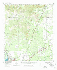
1957 Map of Harriet
USGS Topo · Published 1958About this map
San Angelo's northern expansion meets the open Texas plains in this mid-century survey, anchored by the San Angelo Reservoir and the Concho River. The landscape is a mix of active transportation hubs and fading rural infrastructure, evidenced by the presence of Pulliam Air Force Auxiliary Airfield (Aband) and several closed schoolhouses such as Skinner Sch (Aband) and Kiesling Sch (Aband). To the north, the terrain rises toward Mount Margaret and the distinctive Devils Courthouse Peak, overlooking a network of cattle-country drainages like Mule Creek and Valentine Creek.
Find a feature on this map
52 named features on this map. Tap any name to fly to it.
Don’t see what you’re looking for? This feature index may not catch every label — zoom into the map to look around manually.
Map Details
Editions of this 1957 Harriet Map
2 editions found
Other maps of this area

1891 · Hayrick
USGS Topo · 1:125,000

1892 · San Angelo
USGS Topo · 1:125,000

1894 · Hayrick
USGS Topo · 1:125,000

1895 · Sherwood
USGS Topo · 1:125,000

1921 · Baker Flat
USGS Topo · 1:31,680

1921 · Maverick
USGS Topo · 1:31,680

1921 · Mays School
USGS Topo · 1:31,680

1924 · San Angelo 2-b
USGS Topo · 1:48,000

1924 · Sherwood 1-a
USGS Topo · 1:48,000

1928 · Wall
USGS Topo · 1:62,500