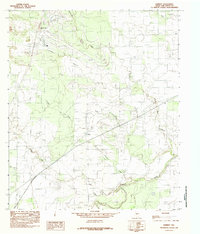
1984 Map of Harriet
USGS Topo · Published 1984About this map
Harriet sits at the center of this West Texas landscape, defined by a complex network of waterways feeding into the Concho River. The 1980s terrain is marked by distinct seasonal drainage patterns, where Tenmile Creek, Crows Nest Creek, and Red Creek carve through the dry country of Tom Green County. Notable landmarks include the prominent Rattle Snake Hill to the northwest and a large Test Facility that occupies a significant portion of the northern quadrant, indicating specialized land use in this period. The survey also captures local industry and recreation through scattered Gravel Pits and a Campground near the river bend. Small water courses like Sales Branch and Valentine Branch provide further detail for researchers tracking historic property boundaries or land development in this rural corridor near San Angelo.
Find a feature on this map
12 named features on this map. Tap any name to fly to it.
Don’t see what you’re looking for? This feature index may not catch every label — zoom into the map to look around manually.
Map Details
Editions of this 1984 Harriet Map
This is the sole edition of this map. No revisions or reprints were ever made.
Other maps of this area

1891 · Hayrick
USGS Topo · 1:125,000

1892 · San Angelo
USGS Topo · 1:125,000

1894 · Hayrick
USGS Topo · 1:125,000

1921 · Baker Flat
USGS Topo · 1:31,680

1924 · San Angelo 2-b
USGS Topo · 1:48,000

1928 · Wall
USGS Topo · 1:62,500

1954 · San Angelo
USGS Topo · 1:250,000

1957 · Eola
USGS Topo · 1:62,500

1957 · Miles
USGS Topo · 1:62,500
1957 · San Angelo South
USGS Topo · 1:24,000