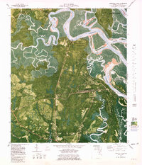
1980 Map of Harrietts Bluff
USGS Topo · Published 1981About this map
John H McIntosh Sugar Mill Site Ruins stand as a historical anchor in this coastal landscape, situated just west of the expanding Kings Bay Naval Submarine Support Base. The map reveals a complex interface of maritime industry and protected wetlands, where the Cumberland River Intracoastal Waterway winds past Cumberland Island National Seashore. The transition from established settlements like Harrietts Bluff and Sadlers Landing to the military installations at Kings Bay illustrates the late 20th-century evolution of Camden County's waterfront. Inland, the community life of the era is marked by several country churches, including St Johns Ch and Young Zion Ch, alongside the St Marys Airport. The inclusion of Crooked River State Park and its Campgrounds highlights the region's longstanding role in coastal recreation and conservation.
Find a feature on this map
46 named features on this map. Tap any name to fly to it.
Don’t see what you’re looking for? This feature index may not catch every label — zoom into the map to look around manually.
Map Details
Editions of this 1980 Harrietts Bluff Map
2 editions found
Other maps of this area

1918 · St Marys
USGS Topo · 1:62,500

1918 · Cumberland Island
USGS Topo · 1:62,500

1918 · Kingsland
USGS Topo · 1:62,500

1919 · Fernandina
USGS Topo · 1:62,500

1919 · St Marys
USGS Topo · 1:62,500

1930 · Cumberland Island
USGS Topo · 1:62,500

1944 · Fernandina
USGS Topo · 1:62,500

1945 · Cumberland Island
USGS Topo · 1:62,500

1948 · Jacksonville
USGS Topo · 1:250,000

1957 · Jacksonville
USGS Topo · 1:250,000