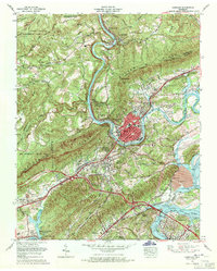
1968 Map of Harriman
USGS Topo · Published 1971About this map
The Emory River winds through the heart of this landscape, marking the transition from the Cumberland Plateau to the valley below. In the late 1960s, the industrial footprint of the Tennessee Valley Authority is unmistakable at the Kingston Steam Plant, where an extensive ash disposal area and skimmer wall sit near the confluence with the Clinch River. This industrial presence contrasts with the older settlement patterns found along Walden Ridge and Grassy Ridge, where small communities like Oakdale and Bazel Town are defined by family-named landmarks such as Snow Cem and Bazel Town Cem.
Find a feature on this map
93 named features on this map. Tap any name to fly to it.
Don’t see what you’re looking for? This feature index may not catch every label — zoom into the map to look around manually.
Map Details
Editions of this 1968 Harriman Map
3 editions found
Other maps of this area

1887 · Kingston
USGS Topo · 1:125,000

1891 · Kingston
USGS Topo · 1:125,000

1893 · Briceville
USGS Topo · 1:125,000

1893 · Kingston
USGS Topo · 1:125,000

1895 · Wartburg
USGS Topo · 1:125,000

1895 · Loudon
USGS Topo · 1:125,000

1895 · Briceville
USGS Topo · 1:125,000

1896 · Wartburg
USGS Topo · 1:125,000

1896 · Briceville
USGS Topo · 1:125,000

1935 · Rockwood
USGS Topo · 1:24,000