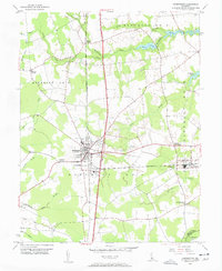
1955 Map of Harrington
USGS Topo · Published 1957About this map
Harrington serves as the central hub of this mid-1950s landscape, where the north-south and east-west lines of the Pennsylvania Railroad intersect. This junction created a thriving agricultural and transit center in Kent County, characterized by small crossroads like Reeves Crossing and Marvels Crossroads. The surrounding terrain is defined by complex drainage networks, including the Murderkill River and several mill ponds like Killen Pond and McCauley Pond, which historically supported local industry. To the south of the main town, the presence of the Fairgrounds and Harrington Airfield indicates the community's role as a regional gathering place. The map captures a transition point in rural Delaware, showing established settlements like Houston and Williamsville alongside smaller family-named landmarks and the St Mark Ch that anchored these farming districts.
Find a feature on this map
39 named features on this map. Tap any name to fly to it.
Don’t see what you’re looking for? This feature index may not catch every label — zoom into the map to look around manually.
Map Details
Editions of this 1955 Harrington Map
3 editions found
Other maps of this area

1899 · Vineland
USGS Topo · 1:125,000

1899 · Dover
USGS Topo · 1:125,000

1906 · Dover
USGS Topo · 1:125,000

1918 · Cedar Creek
USGS Topo · 1:62,500

1918 · Harrington
USGS Topo · 1:62,500

1919 · Cedar Creek
USGS Topo · 1:62,500

1919 · Vineland
USGS Topo · 1:125,000

1920 · Dover
USGS Topo · 1:125,000

1926 · Wyoming
USGS Topo · 1:48,000

1930 · Wyoming
USGS Topo · 1:62,500