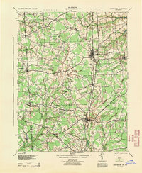
1944 Map of Harrington
USGS Topo · Published 1944About this map
The Pennsylvania railroad corridor serves as the primary north-south spine for this rural landscape, anchoring the bustling depot at Harrington and the smaller station at Farmington. This 1944 edition, revised from 1930s aerial photography, captures a mid-century interior coastal plain defined by a dense network of country schools and family-named intersections. Educational hubs like Piney Grove Sch, Redman Sch, and Sunnyside Sch are scattered among the agricultural fields, while old routes like the Kings Highway thread through the drainage basins of Marshyhope Creek and White Marsh. The map provides a precise look at the Delaware-Maryland border, where the state line bisects small border communities including Whiteleysburg, Burrsville, and Hickman. It is a notable record of a localized geography before the consolidation of rural school districts and modern highway expansion changed the social landscape.
Find a feature on this map
72 named features on this map. Tap any name to fly to it.
Don’t see what you’re looking for? This feature index may not catch every label — zoom into the map to look around manually.
Map Details
Editions of this 1944 Harrington Map
This is the sole edition of this map. No revisions or reprints were ever made.
Other maps of this area

1899 · Vineland
USGS Topo · 1:125,000

1899 · Dover
USGS Topo · 1:125,000

1905 · Denton
USGS Topo · 1:62,500

1905 · Barclay
USGS Topo · 1:62,500

1905 · Hurlock
USGS Topo · 1:62,500

1906 · Dover
USGS Topo · 1:125,000

1915 · Seaford
USGS Topo · 1:62,500

1917 · Millsboro
USGS Topo · 1:62,500

1918 · Cedar Creek
USGS Topo · 1:62,500

1918 · Harrington
USGS Topo · 1:62,500