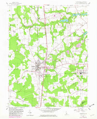
1955 Map of Harrington
USGS Topo · Published 1982About this map
Harrington serves as the central hub of this agricultural landscape in central Delaware, where the Conrail line bisects the town near the Fairgrounds and a local Substation. The map reveals a transition from the structured grid of the town to a terrain defined by slow-moving waterways and wetland fingers, such as Black Swamp Creek and the Murderkill River. To the northeast, the recreational area of Killen Pond State Park surrounds Killen Pond, while several Strip Mine operations appear scattered near the park's southern border.
Find a feature on this map
33 named features on this map. Tap any name to fly to it.
Don’t see what you’re looking for? This feature index may not catch every label — zoom into the map to look around manually.
Map Details
Editions of this 1955 Harrington Map
3 editions found
Other maps of this area

1899 · Vineland
USGS Topo · 1:125,000

1899 · Dover
USGS Topo · 1:125,000

1906 · Dover
USGS Topo · 1:125,000

1918 · Cedar Creek
USGS Topo · 1:62,500

1918 · Harrington
USGS Topo · 1:62,500

1919 · Cedar Creek
USGS Topo · 1:62,500

1919 · Vineland
USGS Topo · 1:125,000

1920 · Dover
USGS Topo · 1:125,000

1926 · Wyoming
USGS Topo · 1:48,000

1930 · Wyoming
USGS Topo · 1:62,500