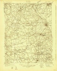
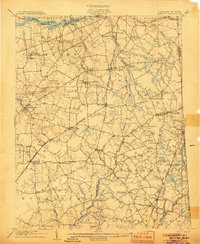
1926 Map of Wyoming
USGS Topo · Published 1926About this map
The Pennsylvania RR corridor anchors this 1926 survey of central Delaware, tracing a line of commerce through Dover, Wyoming, and Camden. To the north, the State College grounds and the County Poor Farm mark significant civic landmarks of the era. The landscape is a dense network of agricultural crossroads and small rural nodes, many identified by family-named junctions like Dinahs Corner, Casson Corner, and Wrights Crossroads.
Find a feature on this map
103 named features on this map. Tap any name to fly to it.
Don’t see what you’re looking for? This feature index may not catch every label — zoom into the map to look around manually.
Map Details
Editions of this 1926 Wyoming Map
This is the sole edition of this map. No revisions or reprints were ever made.
Other maps of this area

1890 · Bay Side
USGS Topo · 1:62,500

1894 · Bay Side
USGS Topo · 1:62,500

1899 · Vineland
USGS Topo · 1:125,000

1899 · Dover
USGS Topo · 1:125,000

1900 · Cecilton
USGS Topo · 1:62,500

1905 · Denton
USGS Topo · 1:62,500
1905 · Barclay
USGS Topo · 1:62,500

1906 · Dover
USGS Topo · 1:125,000
1918 · Cedar Creek
USGS Topo · 1:62,500
1918 · Harrington
USGS Topo · 1:62,500