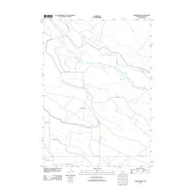
2012 Map of Harris Bridge
USGS Topo · Published 2012About this map
Muddy Ridge dominates the central landscape of this Fremont County quadrangle, situated in an area of Wyoming defined by its network of rural access roads and intermittent waterways. The map illustrates a developed irrigation and ranching infrastructure, where Wyoming Canal Rd and Sheep Camp Rd suggest the region's agricultural and pastoral utility. Water management is central to the area's layout, with the wandering path of Muddy Cr and the more southerly Fivemile Cr providing the primary drainage. The namesake Harris Bridge serves as a vital crossing point in the southwest, while named thoroughfares such as Tunnel Hill Rd and Indian Ridge Rd provide a clear view of the twentieth-century transportation grid used by local landholders and utility companies along the W Powerline Rd corridor.
Find a feature on this map
15 named features on this map. Tap any name to fly to it.
Don’t see what you’re looking for? This feature index may not catch every label — zoom into the map to look around manually.
Map Details
Editions of this 2012 Harris Bridge Map
This is the sole edition of this map. No revisions or reprints were ever made.
Other maps of this area

1950 · Pavillion
USGS Topo · 1:24,000

1950 · Pavillion Butte
USGS Topo · 1:24,000

1950 · Harris Bridge
USGS Topo · 1:24,000

1950 · Mexican Pass SW
USGS Topo · 1:24,000

1950 · Ocean Lake
USGS Topo · 1:24,000

1950 · Shotgun Butte
USGS Topo · 1:24,000

1951 · Mexican Pass
USGS Topo · 1:24,000

1951 · Jenkins Mountain
USGS Topo · 1:24,000

1952 · Lost Wells Butte
USGS Topo · 1:24,000

1955 · Thermopolis
USGS Topo · 1:250,000