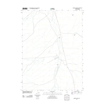
2012 Map of Harris Canyon
USGS Topo · Published 2012About this map
Harris Canyon serves as a central landmark in this Elko County landscape, where the high desert terrain of northeast Nevada is defined by a seasonal drainage network. The small settlement of Shores is situated near the confluence of Willow Creek and Dry Creek, marking a point of human activity along the modern road corridor. These intermittent watercourses, including Jakes Creek and Bull Camp Creek, illustrate the complex hydrology of the Great Basin, where water is a scarce and vital resource. To the northeast, the topography rises toward Rocky Peak, overlooking the broad expanse of Eagle Flat and the isolated Chalk Spring. The presence of the O'Neil Co Rd indicates the importance of long-distance rangeland access in this sparsely populated region, connecting remote ranching areas to the wider county infrastructure.
Find a feature on this map
11 named features on this map. Tap any name to fly to it.
Don’t see what you’re looking for? This feature index may not catch every label — zoom into the map to look around manually.
Map Details
Editions of this 2012 Harris Canyon Map
This is the sole edition of this map. No revisions or reprints were ever made.
Other maps of this area

1955 · Wells
USGS Topo · 1:250,000

1958 · Wells
USGS Topo · 1:250,000

1961 · Wells
USGS Topo · 1:250,000

1968 · Wilkins
USGS Topo · 1:24,000

1968 · Knoll Mountain
USGS Topo · 1:24,000

1968 · Hubbard Basin
USGS Topo · 1:24,000

1968 · Henry
USGS Topo · 1:24,000

1968 · Wine Cup Ranch
USGS Topo · 1:24,000

1968 · Blanchard Mtn
USGS Topo · 1:24,000
1968 · Loomis Mtn
USGS Topo · 1:24,000