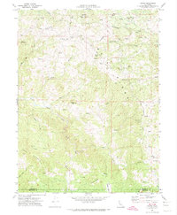
1969 Map of Harris
USGS Topo · Published 1974About this map
Mail Ridge defines the high country of the southern Humboldt and northern Mendocino border during the late 1960s. The small community of Harris serves as the focal point of this ranching and timber landscape, featuring the Harris PO, a Grange Hall, and a local Cem. The settlement pattern follows the ridgelines and narrow creek valleys, with the Muller Ranch and several clearings like Lewis Opening and Peterson Opening dotting the drainages of the East Branch South Fork Eel River.
Find a feature on this map
38 named features on this map. Tap any name to fly to it.
Don’t see what you’re looking for? This feature index may not catch every label — zoom into the map to look around manually.
Map Details
Editions of this 1969 Harris Map
2 editions found
Other maps of this area

1920 · Cummings
USGS Topo · 1:62,500

1920 · Harris
USGS Topo · 1:62,500

1921 · Briceland
USGS Topo · 1:62,500

1949 · Alderpoint
USGS Topo · 1:62,500

1949 · Garberville
USGS Topo · 1:62,500

1950 · Piercy
USGS Topo · 1:62,500

1951 · Alderpoint
USGS Topo · 1:62,500

1951 · Garberville
USGS Topo · 1:62,500

1952 · Leggett
USGS Topo · 1:62,500

1957 · Ukiah
USGS Topo · 1:250,000