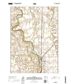
2020 Map of Harrisburg
USGS Topo · Published 2020About this map
The Willamette River meanders through this agricultural corridor at the borders of Linn, Benton, and Lane counties. Its shifting course has created a landscape of riverine landforms, including Ingram Island, Dodge Island, and Morgan Island, as well as several oxbow-related features such as Harkens Lake and Perkins Slough. This region is defined by its deep connections to early Oregon settlement, anchored by the town of Harrisburg and the smaller community of Lancaster. Genealogy and local history are particularly well-represented here through numerous burial sites, including the Halsey Pioneer Cem, the Independent Order of Odd Fellows Cem, and the Lancaster Young Cem. The grid of rural roads like Irish Bend Rd and River Rd N connects these historic settlements and family-named cemeteries, tracing the long-standing land divisions that have shaped the valley's development for generations.
Find a feature on this map
75 named features on this map. Tap any name to fly to it.
Don’t see what you’re looking for? This feature index may not catch every label — zoom into the map to look around manually.
Map Details
Editions of this 2020 Harrisburg Map
This is the sole edition of this map. No revisions or reprints were ever made.
Other maps of this area

1909 · Harrisburg
USGS Topo · 1:31,680

1909 · Rowland
USGS Topo · 1:31,680

1909 · Elmira
USGS Topo · 1:62,500

1910 · Eugene
USGS Topo · 1:62,500

1911 · Monroe
USGS Topo · 1:31,680

1911 · Inavale
USGS Topo · 1:31,680

1912 · Halsey
USGS Topo · 1:62,500

1922 · Monroe
USGS Topo · 1:62,500

1922 · Elmira
USGS Topo · 1:62,500

1939 · Monroe
USGS Topo · 1:62,500