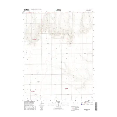
2015 Map of Harrison Flats
USGS Topo · Published 2015About this map
Harrison Flats occupies the open landscape of Wallace County in this 2015 record, illustrating the vast agricultural and topographical character of the High Plains. The northern reach is defined by the sharp elevations of Wallace Bluffs and the etched terrain of Homestead Canyon, where the seasonal drainage of Coon Cr cuts through the township rows. This survey details a precise grid of rural transit, including locally named routes like Ironhorse Rd and Jackrabbit Rd that connect isolated agricultural tracts across the flats. The map provides a clear look at the Public Land Survey System divisions, marking the boundaries of Townships 14 and 15 South, which remain vital for land ownership research and genealogy in this sparsely populated region of Kansas.
Find a feature on this map
22 named features on this map. Tap any name to fly to it.
Don’t see what you’re looking for? This feature index may not catch every label — zoom into the map to look around manually.
Map Details
Editions of this 2015 Harrison Flats Map
This is the sole edition of this map. No revisions or reprints were ever made.
Other maps of this area

1955 · Scott City
USGS Topo · 1:250,000

1958 · Scott City
USGS Topo · 1:250,000

1959 · Wallace
USGS Topo · 1:62,500

1968 · Russell Springs 3 NW
USGS Topo · 1:24,000

1968 · Sharon Springs 4 NW
USGS Topo · 1:24,000

1968 · Sharon Springs 4 NE
USGS Topo · 1:24,000

1969 · Russell Springs 2 NW
USGS Topo · 1:24,000

1969 · Russell Springs 2 SW
USGS Topo · 1:24,000
1979 · Wallace
USGS Topo · 1:24,000
1979 · Sharon Springs East
USGS Topo · 1:24,000