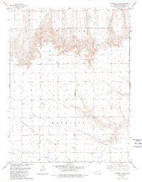
1979 Map of Harrison Flats
USGS Topo · Published 1980About this map
Wallace Bluffs and the level plateau of Harrison Flats define this Western Kansas landscape, where the High Plains drop into a series of drainages. The settlement of Wallace sits at the base of the bluffs, positioned near where Coon Creek meets the broader valley. This 1979 revision, based on aerial photography from the late 1950s and 1970s, captures the rural infrastructure of Wallace County, including the Harrison Flats Sch and Dinas Ch. The map illustrates a strictly surveyed grid of section lines and field boundaries typical of the region's agricultural layout, interrupted only by the winding paths of Twin Butte Creek and Chalk Creek. A major underground pipeline cuts across the flats, reflecting the energy transit role this open country serves alongside its ranching and farming operations.
Find a feature on this map
12 named features on this map. Tap any name to fly to it.
Don’t see what you’re looking for? This feature index may not catch every label — zoom into the map to look around manually.
Map Details
Editions of this 1979 Harrison Flats Map
This is the sole edition of this map. No revisions or reprints were ever made.
Other maps of this area

1955 · Scott City
USGS Topo · 1:250,000

1958 · Scott City
USGS Topo · 1:250,000

1959 · Wallace
USGS Topo · 1:62,500

1968 · Russell Springs 3 NW
USGS Topo · 1:24,000

1968 · Sharon Springs 4 NW
USGS Topo · 1:24,000

1968 · Sharon Springs 4 NE
USGS Topo · 1:24,000

1969 · Russell Springs 2 NW
USGS Topo · 1:24,000

1969 · Russell Springs 2 SW
USGS Topo · 1:24,000
1979 · Wallace
USGS Topo · 1:24,000
1979 · Sharon Springs East
USGS Topo · 1:24,000