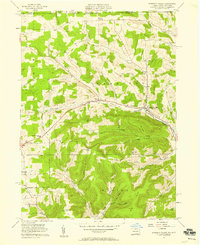
1957 Map of Harrison Valley
USGS Topo · Published 1958About this map
Harrison Valley and Mills serve as the primary hubs along the Cowanesque River in this mid-century portrait of northern Potter County. The landscape is defined by deep, named hollows such as Dodge Hollow, Teed Hollow, and Baldwin Hollow, which drain from the elevated Big Level. This era shows a transition in transportation, where the Old Railroad Grade—formerly a vital lumber and freight artery—runs parallel to the river, bypassed by modern developments like the Radar Tower on Bailey Hill.
Find a feature on this map
46 named features on this map. Tap any name to fly to it.
Don’t see what you’re looking for? This feature index may not catch every label — zoom into the map to look around manually.
Map Details
Editions of this 1957 Harrison Valley Map
Other maps of this area

1899 · Gaines
USGS Topo · 1:62,500

1900 · Gaines
USGS Topo · 1:62,500

1926 · Wellsville
USGS Topo · 1:62,500

1926 · Greenwood
USGS Topo · 1:62,500

1932 · Genesee
USGS Topo · 1:62,500

1937 · Genesee
USGS Topo · 1:62,500

1950 · Elmira
USGS Topo · 1:250,000

1954 · Williamsport
USGS Topo · 1:250,000

1954 · Troupsburg
USGS Topo · 1:24,000
1957 · Potter Brook
USGS Topo · 1:24,000