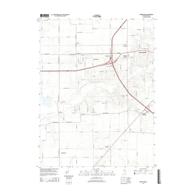
2015 Map of Harristown
USGS Topo · Published 2015About this map
The Sangamon River winds through this central Illinois landscape west of Decatur, anchoring a region of small farming settlements and historical family landmarks. The village of Harristown sits along the northern rail and road corridor, while Boody and Blackland mark the southwestern transition toward open prairie. Local history is deeply etched into the land through numerous rural burying grounds, including Harristown Cem, Muirheid Cem, and the Salem Cem near Bulldog Crossing. This modern survey details a complex intersection of transportation and heritage, featuring the Lincoln Memorial Pky and the Lincoln Trail Bridge. The map records a landscape where established communities like Wyckles Corners persist alongside natural features like Spring Cr and Stevens Creek, illustrating the enduring spatial organization of Macon County.
Find a feature on this map
100 named features on this map. Tap any name to fly to it.
Don’t see what you’re looking for? This feature index may not catch every label — zoom into the map to look around manually.
Map Details
Editions of this 2015 Harristown Map
This is the sole edition of this map. No revisions or reprints were ever made.
Other maps of this area

1929 · Decatur
USGS Topo · 1:62,500

1933 · Decatur
USGS Topo · 1:62,500

1949 · Dalton City
USGS Topo · 1:62,500

1952 · Assumption
USGS Topo · 1:62,500

1954 · Niantic
USGS Topo · 1:62,500

1958 · Decatur
USGS Topo · 1:250,000

1961 · Decatur
USGS Topo · 1:250,000

1967 · Decatur
USGS Topo · 1:24,000
1967 · Forsyth
USGS Topo · 1:24,000

1982 · Harristown
USGS Topo · 1:24,000