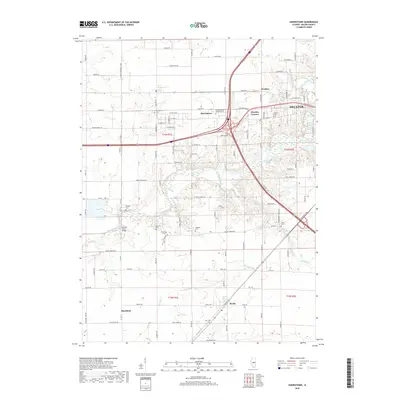
2018 Map of Harristown
USGS Topo · Published 2018About this map
The Sangamon River carves through this central Illinois landscape, defining the transition between the agricultural plains and the westward expansion of Decatur. Near the river's edge, the Lincoln Trail Bridge marks a crossing point in an area dense with small family and community burial grounds, including the Muirheid Cem, Brown Cem, and Whitley Cem. These sites, along with the larger Macon County Memorial Park, provide significant touchstones for genealogical research in the townships of Harristown and Blue Mound.
Find a feature on this map
109 named features on this map. Tap any name to fly to it.
Don’t see what you’re looking for? This feature index may not catch every label — zoom into the map to look around manually.
Map Details
Editions of this 2018 Harristown Map
This is the sole edition of this map. No revisions or reprints were ever made.
Other maps of this area

1929 · Decatur
USGS Topo · 1:62,500

1933 · Decatur
USGS Topo · 1:62,500

1949 · Dalton City
USGS Topo · 1:62,500

1952 · Assumption
USGS Topo · 1:62,500

1954 · Niantic
USGS Topo · 1:62,500

1958 · Decatur
USGS Topo · 1:250,000

1961 · Decatur
USGS Topo · 1:250,000

1967 · Decatur
USGS Topo · 1:24,000
1967 · Forsyth
USGS Topo · 1:24,000

1982 · Harristown
USGS Topo · 1:24,000