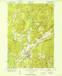
1951 Map of Harrisville
USGS Topo · Published 1952About this map
Harrisville serves as the primary hub of this 1951 landscape, situated at the confluence of the West Branch Oswegatchie River and several minor tributaries. The area is defined by its transition from the settled valley floor to the prominent heights of Baldface Hill and Cooper Hill. Transportation in this era relied heavily on the New York Central rail line, which snakes through the terrain alongside the river, connecting remote outposts like Pitcairn and Geers Corners to the broader region.
Find a feature on this map
49 named features on this map. Tap any name to fly to it.
Don’t see what you’re looking for? This feature index may not catch every label — zoom into the map to look around manually.
Map Details
Editions of this 1951 Harrisville Map
4 editions found
Other maps of this area

1913 · Lake Bonaparte
USGS Topo · 1:62,500

1915 · Gouverneur
USGS Topo · 1:62,500

1915 · Russell
USGS Topo · 1:62,500

1916 · Lake Bonaparte
USGS Topo · 1:62,500

1916 · Oswegatchie
USGS Topo · 1:62,500

1918 · Russell
USGS Topo · 1:62,500

1918 · Oswegatchie
USGS Topo · 1:62,500

1937 · Gouverneur
USGS Topo · 1:62,500

1948 · Ogdensburg
USGS Topo · 1:250,000

1951 · Ogdensburg
USGS Topo · 1:250,000