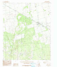
1983 Map of Harrold
USGS Topo · Published 1991About this map
Harrold serves as the primary focal point of this North Texas landscape, situated along a prominent transportation corridor where the railroad and highway intersect. The settlement is characterized by a compact grid of streets, a local Cem, and infrastructure that speaks to the agricultural and transit-based economy of Wilbarger County. The surrounding terrain is defined by a dendritic network of waterways, including Rock Creek and Bull Creek, which flow southward through the prairie toward the southern edge of the survey area.
Find a feature on this map
7 named features on this map. Tap any name to fly to it.
Don’t see what you’re looking for? This feature index may not catch every label — zoom into the map to look around manually.
Map Details
Editions of this 1983 Harrold Map
2 editions found
Other maps of this area

1916 · Electra
USGS Topo · 1:24,000

1917 · Beaver Creek
USGS Topo · 1:24,000

1918 · Electra
USGS Topo · 1:31,680

1920 · Beaver Creek
USGS Topo · 1:31,680

1954 · Wichita Falls
USGS Topo · 1:250,000

1955 · Lawton
USGS Topo · 1:250,000

1958 · Wichita Falls
USGS Topo · 1:250,000

1958 · Davidson
USGS Topo · 1:62,500

1958 · Electra
USGS Topo · 1:62,500

1966 · Grayback
USGS Topo · 1:24,000