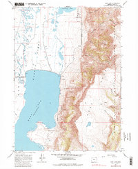
1967 Map of Hart Lake
USGS Topo · Published 1984About this map
Hart Mountain National Antelope Refuge dominates the eastern landscape of this survey, where the dramatic rise of the Hart Mountain massif meets the high desert basin of the Warner Lakes chain. The water levels of Hart Lake are precisely recorded at a normal pool elevation of 4473 feet, regulated by a spillway near a small gravel pit and sandpit. The terrain transitions sharply from the seasonal wetlands of Alkali Flat and Honey Cr in the west to a series of steep, named drainages including Arsenic Canyon, De Garmo Canyon, and Potter Canyon to the east. This 1960s perspective captures the area's essential hydrology, from the well and pump infrastructure in the valley to the various springs that dot the refuge slopes, providing a clear view of the wildlife sanctuary's geography before later environmental shifts.
Find a feature on this map
22 named features on this map. Tap any name to fly to it.
Don’t see what you’re looking for? This feature index may not catch every label — zoom into the map to look around manually.
Map Details
Editions of this 1967 Hart Lake Map
3 editions found

Other maps of this area

1955 · Adel
USGS Topo · 1:250,000

1957 · Adel
USGS Topo · 1:250,000

1958 · Adel
USGS Topo · 1:250,000

1962 · Adel
USGS Topo · 1:250,000

1967 · Flagstaff Lake
USGS Topo · 1:24,000

1967 · Jacobs Reservoir
USGS Topo · 1:24,000

1967 · Plush
USGS Topo · 1:24,000

1967 · Rabbit Hills SW
USGS Topo · 1:24,000

1967 · Priday Reservoir
USGS Topo · 1:24,000

1967 · Campbell Lake
USGS Topo · 1:24,000