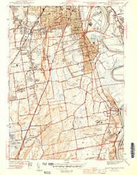
1944 Map of Hartford South
USGS Topo · Published 1944About this map
The Connecticut River forms the eastern spine of this mid-century landscape, where the agricultural flats of Wethersfield and South Wethersfield meet the industrial and institutional expansion of the wartime era. Surveyed during the height of the 1940s, the map documents a transition from the village centers of Rocky Hill and Newington to a more complex urban-suburban interface. Large-scale institutional footprints are prominent, including the State Prison near The Cove, the State Veterans Home, and the State Institute for Blind.
Find a feature on this map
74 named features on this map. Tap any name to fly to it.
Don’t see what you’re looking for? This feature index may not catch every label — zoom into the map to look around manually.
Map Details
Editions of this 1944 Hartford South Map
3 editions found

Other maps of this area

1892 · Hartford
USGS Topo · 1:62,500

1892 · Meriden
USGS Topo · 1:62,500

1892 · Granby
USGS Topo · 1:62,500

1893 · Middletown
USGS Topo · 1:62,500

1893 · Meriden
USGS Topo · 1:62,500

1906 · Farmington
USGS Topo · 1:125,000

1928 · Cromwell
USGS Topo · 1:24,000

1928 · Windsor
USGS Topo · 1:24,000

1928 · Glastonbury
USGS Topo · 1:24,000

1928 · Manchester
USGS Topo · 1:24,000