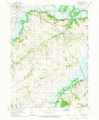
1965 Map of Hartford
USGS Topo · Published 1966About this map
The Des Moines River valley dominates this mid-1960s landscape, illustrating the intersection of natural waterways and civil engineering. The mapping of Lake Red Rock at its normal pool elevation reflects a significant era of flood control and land management in the region. Transportation and industry are anchored by the Chicago Rock Island and Pacific railroad corridor, which skirts the northern edge near Carlisle.
Find a feature on this map
26 named features on this map. Tap any name to fly to it.
Don’t see what you’re looking for? This feature index may not catch every label — zoom into the map to look around manually.
Map Details
Editions of this 1965 Hartford Map
This is the sole edition of this map. No revisions or reprints were ever made.
Other maps of this area

1905 · Des Moines
USGS Topo · 1:62,500

1907 · Des Moines
USGS Topo · 1:62,500

1910 · Milo
USGS Topo · 1:62,500

1930 · Mitchellville
USGS Topo · 1:62,500

1931 · Indianola
USGS Topo · 1:62,500

1954 · Des Moines
USGS Topo · 1:250,000

1956 · Des Moines
USGS Topo · 1:250,000

1956 · Des Moines SE
USGS Topo · 1:24,000

1956 · Des Moines
USGS Topo · 1:62,500

1957 · Des Moines
USGS Topo · 1:250,000