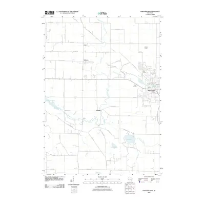
2010 Map of Hartford West
USGS Topo · Published 2010About this map
Hartford and its western rural surroundings are defined by a complex network of waterways and early twentieth-century infrastructure. The Rubicon River winds through the landscape, feeding the Hartford Millpond at the Hartford-1855C14 Dam, while the Ashippun River drains the southern portion of the quadrangle near Druid Lake. This 2010 survey illustrates a mix of small-town development and agricultural heritage, with the settlements of Rubicon and Saylesville remaining as key regional nodes. Local history is anchored by several long-standing burial grounds, including Saint Killian Cemetery and Hallowell Cemetery. The presence of the Hartford Municipal Airport and modern industrial naming conventions like Innovation Way contrast with the older mill-based hydrology of Neosho Millpond, showing the gradual evolution of Washington County from a water-powered economy to a contemporary transportation and light-industrial hub.
Find a feature on this map
68 named features on this map. Tap any name to fly to it.
Don’t see what you’re looking for? This feature index may not catch every label — zoom into the map to look around manually.
Map Details
Editions of this 2010 Hartford West Map
This is the sole edition of this map. No revisions or reprints were ever made.
Other maps of this area

1892 · Watertown
USGS Topo · 1:62,500

1892 · Oconomowoc
USGS Topo · 1:62,500

1894 · Watertown
USGS Topo · 1:62,500

1904 · Hartford
USGS Topo · 1:62,500

1909 · Oconomowoc
USGS Topo · 1:62,500

1955 · Horicon
USGS Topo · 1:62,500

1957 · Madison
USGS Topo · 1:250,000

1959 · Ixonia
USGS Topo · 1:24,000
1959 · Stonebank
USGS Topo · 1:24,000

1959 · Hartford
USGS Topo · 1:62,500