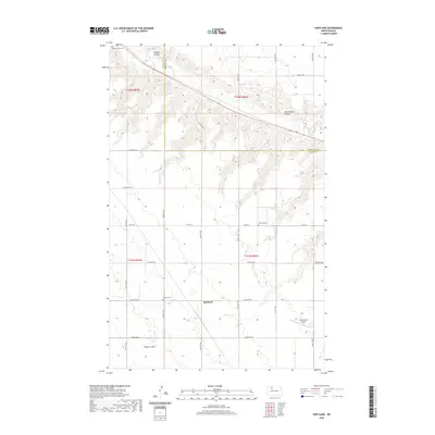
2020 Map of Hartland
USGS Topo · Published 2020About this map
Hartland sits at a crossroads of prairie history along the border of Ward and Renville Counties. The landscape is defined by the winding course of the Des Lacs River and the deeply etched drainage patterns of Goettle Coulee, Carl Feldner Coulee, and Flaten Coulee. This agricultural corridor is marked by several small rural cemeteries that anchor the local heritage, including Saint Anthony Cem in the northwest and Hillside Cem near the town center. The presence of Skinningsrud Airport to the east and the systematic grid of county roads like Co Hwy 6 illustrate the modern transportation network laid over the traditional Public Land Survey System. The map captures the subtle transition between flat upland plains and the more varied terrain flanking the river valley.
Find a feature on this map
23 named features on this map. Tap any name to fly to it.
Don’t see what you’re looking for? This feature index may not catch every label — zoom into the map to look around manually.
Map Details
Editions of this 2020 Hartland Map
This is the sole edition of this map. No revisions or reprints were ever made.
Other maps of this area

1947 · Tolley
USGS Topo · 1:62,500

1948 · Donnybrook
USGS Topo · 1:24,000

1949 · Tolley SE
USGS Topo · 1:24,000

1949 · Hartland
USGS Topo · 1:24,000

1949 · Carpio
USGS Topo · 1:24,000

1949 · Grano SW
USGS Topo · 1:24,000

1950 · Tolley
USGS Topo · 1:62,500
1951 · Grano
USGS Topo · 1:62,500

1954 · Minot
USGS Topo · 1:250,000

1958 · Minot
USGS Topo · 1:250,000