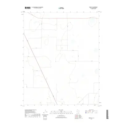
2019 Map of Hartley SE
USGS Topo · Published 2019About this map
Large-scale agriculture and cattle ranching define this portion of Hartley County, characterized by a grid of rural roads and expansive open country. The intersection of major thoroughfares 87 and 385 provides the primary transit corridor through the High Plains landscape, while smaller local arteries like Snyder Rd and Fords Rd serve the surrounding farmsteads. Several ephemeral water bodies and depressions are scattered across the quadrangle, typical of the regional topography. The mapping of routes such as Co Rd 41 and Fm 722 reveals a community connected by a network of well-defined section lines, typical of the Panhandle's 21st-century rural infrastructure.
Find a feature on this map
11 named features on this map. Tap any name to fly to it.
Don’t see what you’re looking for? This feature index may not catch every label — zoom into the map to look around manually.
Map Details
Editions of this 2019 Hartley SE Map
This is the sole edition of this map. No revisions or reprints were ever made.
Other maps of this area

1954 · Tucumcari
USGS Topo · 1:250,000

1958 · Tucumcari
USGS Topo · 1:250,000

1963 · Hartley SE
USGS Topo · 1:24,000

1963 · Hartley NE
USGS Topo · 1:24,000

1963 · Bird Ranch Store
USGS Topo · 1:24,000

1963 · Moran Ranch
USGS Topo · 1:24,000

1971 · Bivins Channing Ranch
USGS Topo · 1:24,000

1971 · Channing NW
USGS Topo · 1:24,000
1971 · Channing
USGS Topo · 1:24,000

1972 · Hartley SW
USGS Topo · 1:24,000