
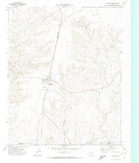
1963 Map of Hartley SE
USGS Topo · Published 1966About this map
Large cattle ranches and the rail corridor of the Fort Worth and Denver define this portion of the Texas Panhandle in the early 1960s. The landscape is marked by numerous ephemeral lakes and basins, which dot the high plains across this sector of Hartley County. Settlement is sparse and focused on localized ranching operations, such as Bryant Ranch in the west, Beale Queen Ranch near the center of the sheet, and Edlin Ranch in the southeast. Resource extraction begins to appear on the landscape during this era, indicated by a Gas Well in the south. The map provides a precise look at the land use patterns and property boundaries in this corner of the Llano Estacado, where the iron rails of the Fort Worth and Denver create a singular diagonal line through the otherwise grid-patterned ranchland.
Find a feature on this map
6 named features on this map. Tap any name to fly to it.
Don’t see what you’re looking for? This feature index may not catch every label — zoom into the map to look around manually.
Map Details
Editions of this 1963 Hartley SE Map
This is the sole edition of this map. No revisions or reprints were ever made.
Other maps of this area

1954 · Tucumcari
USGS Topo · 1:250,000

1958 · Tucumcari
USGS Topo · 1:250,000

1963 · Hartley NE
USGS Topo · 1:24,000

1963 · Bird Ranch Store
USGS Topo · 1:24,000

1963 · Moran Ranch
USGS Topo · 1:24,000

1971 · Bivins Channing Ranch
USGS Topo · 1:24,000

1971 · Channing NW
USGS Topo · 1:24,000
1971 · Channing
USGS Topo · 1:24,000

1972 · Hartley SW
USGS Topo · 1:24,000

1973 · Hartley
USGS Topo · 1:24,000